Larch season in Washington is short but spectacular. From late September to mid-October, these golden conifers draw hikers from across the Pacific Northwest. To help families plan, we’ve rounded up the best larch hikes near Seattle — from easy lookouts to icons like Blue Lake and Maple Pass — plus tips on timing, passes, and making the most of your day with kids.
What is a larch?
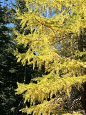
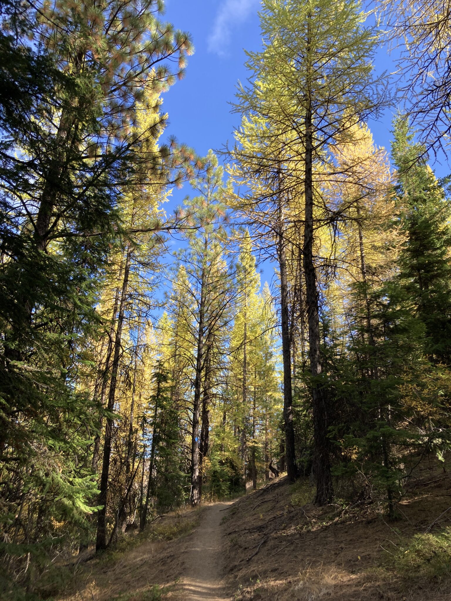
A larch is a unique conifer tree. Unlike most evergreens that keep their needles year-round, larches are deciduous conifers: their soft green needles turn a brilliant golden color in the fall before dropping to the ground.
In Washington, larches usually turn gold between late September and mid-October, depending on elevation and weather. This short “golden window” can vary year to year, so it’s smart to check current hiking reports for both trail conditions and larch status. Reading the latest trip report comments is often the best way to confirm if the larches are glowing.
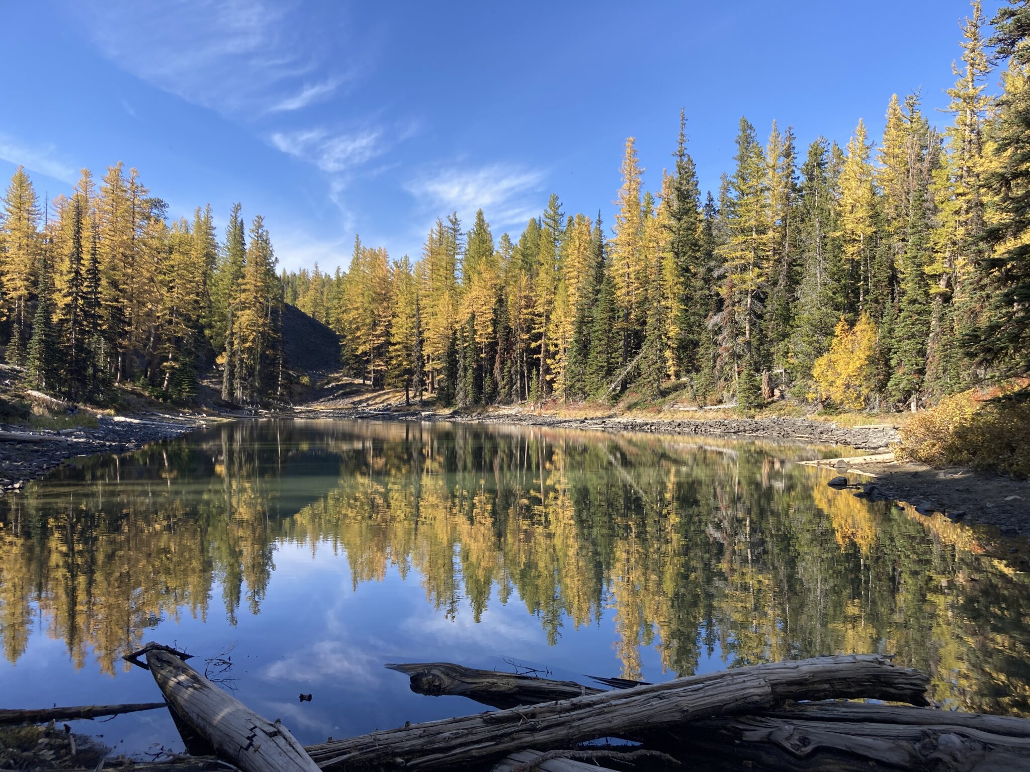
Larches are one of the few conifers that turn gold before shedding their needles. (Image: Godfrey Guerzon)
FAQs about Washington larches
When is larch season in Washington?
Typically late September to mid-October; peak varies by elevation. Check WTA trip reports before heading out.
Where can you see larches in Washington?
North Cascades (Blue Lake, Maple Pass), Teanaway (Red Top), Wenatchee (Clara/Marion Lakes).
What are the best larch hikes for families?
Blue Lake, Red Top Lookout, Swauk Forest Discovery Trail, Clara/Marion Lakes.
How do I avoid larch hike crowds?
Go early, choose weekdays, and try quieter alternatives like Swauk or Clara/Marion.
Do I need a pass?
Most require a NW Forest Pass (or America the Beautiful). Always check ahead.
Kid-friendly larch hikes
Here are some kid-friendly larch hikes that will allow you to experience these natural beauties. Recommended hikes range from easy to hard and depend on you and your child’s hiking ability. Remember to check the weather before heading out, check trip reports, and pack the 10 essentials for your outing.
Red Top Lookout larches (short + kid-friendly)
- Co-ordinates: 47.2970, -120.7596
- Distance: 1.5 miles, round-trip
- Elevation gain: 350 feet
- Difficulty: Easy
- Parking Pass/ Entry Fee: NW Forest Pass
- Ages: All
A short and steep hike through the forest will lead you to a functioning fire lookout and gorgeous 360-degree views of the Enchantments and Stuart Range. With a bit of luck and the right timing, those beautiful golden larches will also be in view during the fall months. This is a very kid-friendly hike and an excellent way for the whole family to view larches.
Tips: Some reviews have mentioned that the gravel road to the trailhead is a bit rough and bumpy. Please make sure your vehicle has clearance before heading out for this hike.
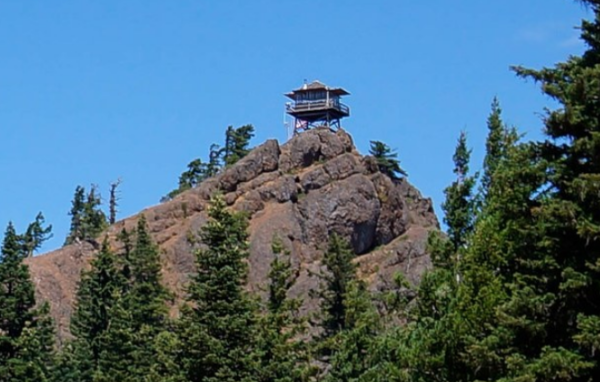
Red Top Lookout is a short, kid-friendly hike with sweeping fall views and golden larches. (Image courtesy WTA)
Swauk Forest Discovery Trail (educational + accessible)
- Coordinates: 47.3354, -120.5790
- Distance: 2.5 miles
- Elevation Gain: 660
- Difficulty: Easy-Moderate
- Parking Pass: NW Forest Pass
- Ages: All
This kid- and dog-friendly trail near the summit of Blewett Pass is a great hike for both larches and autumn color. The 25 interpretive signs offer information on forest ecology and tree identification. The loop trail can be taken in either direction, but I suggest going counterclockwise, which means the elevation gain is more gradual. The tree identification signs are worth checking out; my favorite was near a big Ponderosa Pine next to the trail, inviting you to smell the bark. The sign said that the bark smells like butterscotch or vanilla, and it really did! (I smelled butterscotch; my husband smelled vanilla.) We saw lots of “baby” larches (saplings) planted near the trail that had turned yellow. The highest point is marker 21, from which you can see a sweeping view of the surrounding mountains, including Mt. Rainier, on a clear day.
Here, there is a short section of a ridge trail where the trail narrows, and the ground slopes down on either side, so watch kids carefully on this section. Several log benches along the way allow for resting or having a snack break.
Though the larches weren’t in large groups, there was plenty to see, and when the sun shone through them, it was truly magical. Some other things to look for are bits of neon green moss clinging to many of the trees, quite different from the moss we see in the Seattle area. We even found some on the ground, and the texture was stiff and spiky, like a Brillo pad. Depending on when you go, you might see larches in various stages of turning. We saw larches that were lime green, bright yellow, golden, and in between. Also of note, there were so many pinecones on the ground, and the variety in size was interesting. The Ponderosa pine cones were huge.
Tips: The port-o-potties were locked, and the toilets were full and had no toilet paper. I recommend making a pit stop on the drive to this hike to avoid this bathroom if possible. The road is full of big potholes. Be careful if you are driving a car with low clearance. The kiosk at the trailhead was supposed to have guides, but it was empty. Here is a link from which you can print the brochure to bring with you. There is a trail map on the kiosk at the trailhead. It’s a good idea to snap a photo of the map with your phone if you don’t have directions downloaded and lose service.
Swauk Forest Discovery Trail is a family-friendly hike where larches glow overhead each fall. (Image: Godfrey Guerzon)
Blue Lake larches (North Cascades classic)
- Co-ordinates: 48.5191, -120.6742
- Distance: 4.4 miles, round-trip
- Elevation gain: 1,050 feet
- Difficulty: Moderate
- Parking Pass/Entry Fee: NW Forest Pass
- Ages: Upper-elementary, tweens, teens, adults
Blue Lake is one of the most popular larch hikes in Washington because of its easy access and iconic alpine views. It’s a family-friendly hike to those golden larches, but it offers more of a challenge. Some call this hike an absolute favorite and must-do for its ease of access and spectacular scenery. With the trailhead conveniently located right off Highway 20, you’ll be out of the car and climbing through the forest in no time. After trekking through a meadow and maneuvering a small creek crossing, you’ll see an old log cabin near the lakeside. Watch for goats, as they have been seen wandering here occasionally.
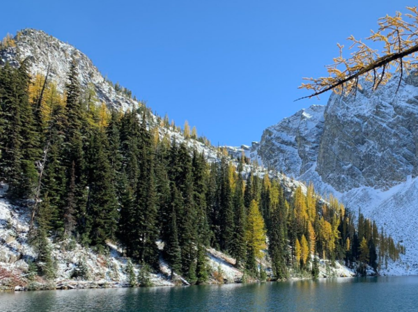
Blue Lake is one of Washington’s most popular larch hikes, famous for its alpine scenery. (Image courtesy WTA)
Clara & Marion Lakes (quiet Wenatchee option)
- Coordinates: 47.2942, -120.3987
- Distance: 3.2 miles
- Elevation Gain: 900 feet
- Difficulty: Moderate
- Parking Pass: None
- Ages: Upper-elementary, tweens, adults
Mission Ridge Ski Area’s parking lot in Wenatchee is where this beautiful hike begins. Although it is only three miles and has 900 ft of elevation gain, that first half is a leg burner. The trail is dusty and often rocky and uneven. As soon as you step on the trail, you go up and up on steep switchbacks. But the incline is worth it as you wind through a dense forest of evergreen trees dotted with fall foliage in hues of yellow, russet, and orange.
Keep an eye out for chipmunks. We saw several of these cute critters bouncing around both on the way up and at the lake. Once you reach the top, it flattens out into a meadow, and within a few steps, you arrive at Lake Clara. The view here is breathtaking. A small, clear lake surrounded by groves of bright yellow larches, perfectly reflected in the still water. Walk around and take in the view from different spots along the shore. This is a great spot to sit and snack or skip rocks. We saw a few chipmunks there, too.
You can go another quarter mile up to Marion Lake, but other hikers told us it was almost completely dried up, so we turned around and enjoyed Lake Clara some more.
Tips: We saw plenty of upper elementary-aged kids and tweens on the trail, but because of the climb, I wouldn’t recommend this trail for younger kiddos unless you know they are up for the challenge. I also recommend good shoes and poles for adults if you have them, especially for the way down. There are a couple of forks in the trail, but these had good signs to point them in the right direction. That being said, we used AllTrails as a guide.
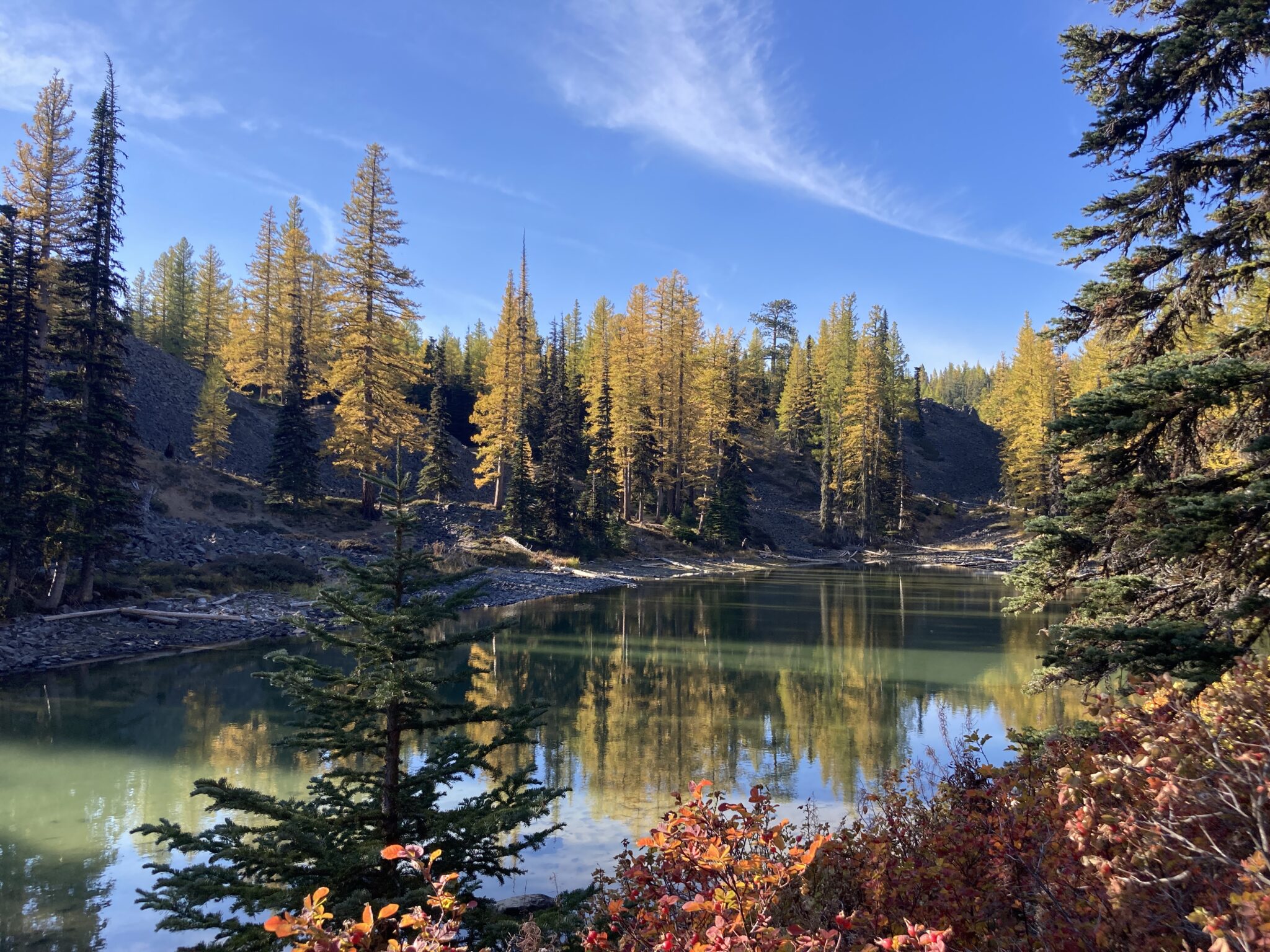
Clara Lake glows with golden larches each fall, offering a peaceful alternative to busier trails like Blue Lake or Maple Pass. (Image: Godfrey Guerzon)
Maple Pass larches (loop with iconic views)
Note: The Rainy Pass parking lot will be closed Sept 8–25 for trailhead repairs.
- Co-ordinates: 48.5162, -120.7354
- Distance: 7.2 miles, roundtrip
- Elevation gain: 2,020 feet
- Difficulty: Hard
- Parking Pass/Entry Fee: NW Forest Pass
- Ages: Teens and adults
Heather-Maple Pass is where we start to get into the more challenging hikes to Washington larches. This hike is rated as moderate to difficult at 7.2 miles round-trip and an elevation gain of 2,020 feet. However, the trail is well-maintained and worth the challenge of seeing those larches. This hike is typically done counterclockwise, leaving from the trailhead. A few offshoot trails branch off the main trail to Heather Pass, so stay alert. About 1.25 miles in, a fork goes to Lake Ann. The detour is a relatively flat 0.6 miles and well worth the stop. Back on the main trail to Heather Pass, you’ll encounter mountain ridgelines, switchbacks, and stunning views that take your breath away.
Tips: Although this loop hike can be done in either direction, most hike it counterclockwise. This is because going counterclockwise allows you to have a more gradual ascent with the best views of Maple Pass in front of you. Hiking this loop clockwise starts your hike with a pretty brutal climb, but it can be done this way if you want more of a challenge. Be sure to take advantage of being in such a gorgeous area and stop at the Diablo Lake Overlook to take in the breathtaking views of this turquoise lake.
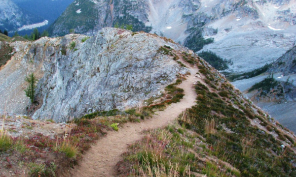
This challenging loop rewards hikers with some of the best larch scenery in Washington. (Image courtesy WTA)
Planning Tips for Families
Because larch season can be short, crowded, and unpredictable, here are tips to make your family trip smoother.
- Timing: Peak shifts yearly; aim for flexibility.
- Gear: Layers, traction, and the 10 essentials.
- Crowds: Weekdays + early starts = sanity savers.
- Family tips: Bring snacks, allow time for photo stops, pack extra warm gear for kids.
- Leave No Trace: Stay on trails to protect fragile meadows.
- Need More? If you want more fall color beyond larches, don’t miss our roundup of kid-friendly fall hikes around Seattle.